File:South Sudan - Location Map (2012) - SSD - UNOCHA.svg

Virsioni a àuta risuluzzioni (File SVG, diminzioni numinali 254 × 254 pixel, grannizza dû file: 456 KB)
Discrizzioni
| Discrizzioni |
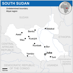
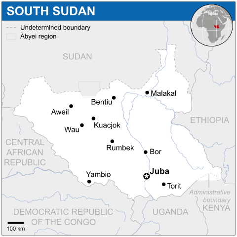
English: Locator map of South Sudan. |
| Data | |
| Fonti |
English: South Sudan Locator Map (ReliefWeb) |
| Auturi | |
| SVG sviluppo | Questa mappa in grafica vettoriale è stata creata con Adobe Illustrator. |

_-_SSD_-_UNOCHA.svg)
Licenza
- Sî lìbbiru:
- di cunnivìdiri – di cupiari, diffùnniri e trasmèttiri st'òpira
- di canciari – d'adattari l'òpira
- Sutta ê siguenti cunnizzioni:
- attribbuzzioni – Hai a dari attribbuzzioni di l'òpira â manera spicificata dû sò auturi o dû titulari dâ licenza (pirò no a na manera chi pò fari pinzari chi iddi sustèninu o a tìa o lu tò utilizzu dâ sò òpira)
 This map is part of a collection of 216 free country maps, created by the UN Office for the Coordination of Humanitarian Affairs (OCHA), to be used in print, web or broadcast products.
The ReliefWeb Location Maps released here are maps that highlight a country, its capital, major populated places and the surrounding regions. Attribution Requirements
Using the map without modifications: ensure that the sources and the disclaimer are below the map. Credit as follows: "Credit: OCHA". For use with alteration: remove the OCHA logo and disclaimer following any modification to the map, but keep the data sources as mentioned below the map. Credit the modified map as follows: "Based on OCHA map". You are responsible for the content of your map. We are keen to receive your feedback and hear how you used OCHA's maps. We would be grateful if you would notify us by e-mail and share your work with us. UN Disclaimer
The designations employed and the presentation of material of this map do not imply the expression of any opinion whatsoever on the part of the Secretariat of the United Nations concerning the legal status of any country, territory, city or area or of its authorities or concerning the delimitation of its frontiers or boundaries. |
Cronoluggìa dû file
Fari clic supra un gruppu data/ura pi vìdiri lu file comu si prisintava ntô mumentu nnicatu.
| Data/Ura | Miniatura | Diminsioni | Utenti | Oggettu | |
|---|---|---|---|---|---|
| currenti | 05:38, 18 nuv 2014 | | 254 × 254 (456 KB) | Pharos | try without logo for now |
| 03:14, 8 maiu 2014 |  | 254 × 254 (374 KB) | UN OCHA maps bot | == {{int:filedesc}} == {{Information |description={{en|1=Locator map of South Sudan.}} |date=2012 |source={{en|1=[http://reliefweb.int/map/south-sudan-republic/south-sudan-location-map-2012 South Sudan Locator Map (ReliefWeb)]}} |a... |
Pàggini c'ùsanu sta mmàggini
Li pàggini siquenti richiàmanu sta mmàggini:
Utilizzu glubbali dû file
Puru li wiki appressu ùsanu stu file:
- Utilizzu supra bh.wikipedia.org
- Utilizzu supra eu.wikipedia.org
- Utilizzu supra hu.wikipedia.org
- Utilizzu supra id.wikipedia.org
- Utilizzu supra pl.wikipedia.org
- Utilizzu supra sco.wikipedia.org
- Utilizzu supra simple.wikipedia.org
- Utilizzu supra st.wikipedia.org
- Utilizzu supra trv.wikipedia.org
- Utilizzu supra uk.wikipedia.org
- Utilizzu supra zh.wikipedia.org
_-_SSD_-_UNOCHA.svg)