File:Umbriel (moon).jpg
Nun sunnu dispunìbbili virsioni a risuluzzioni cchiù elivata.
Umbriel_(moon).jpg (291 × 302 pixel, grannizza dû file: 25 KB, tipu MIME: image/jpeg)
.jpg)
Discrizzioni
| Discrizzioni |
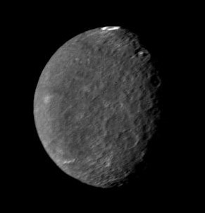
English: Original Caption Released with Image: The southern hemisphere of Umbriel displays heavy cratering in this Voyager 2 image, taken Jan. 24, 1986, from a distance of 557,000 kilometers (346,000 miles). This frame, taken through the clear-filter of Voyager's narrow-angle camera, is the most detailed image of Umbriel, with a resolution of about 10 km (6 mi). Umbriel is the darkest of Uranus' larger moons and the one that appears to have experienced the lowest level of geological activity. It has a diameter of about 1,200 km (750 mi) and reflects only 16 percent of the light striking its surface; in the latter respect, Umbriel is similar to lunar highland areas. Umbriel is heavily cratered but lacks the numerous bright ray craters seen on the other large Uranian satellites; this results in a relatively uniform surface albedo (reflectivity). The prominent crater on the terminator (upper right) is about 110 km (70 mi) across and has a bright central peak. The strangest feature in this image (at top) is a curious bright ring, the most reflective area seen on Umbriel. The ring is about 140 km (90 miles) in diameter and lies near the satellite's equator. The nature of the ring is not known, although it might be a frost deposit, perhaps associated with an impact crater. Spots against the black background are due to 'noise' in the data. The Voyager project is managed for NASA by the Jet Propulsion Laboratory. |
| Data | |
| Fonti | http://photojournal.jpl.nasa.gov/catalog/PIA00040 |
| Auturi | NASA |
| Àutri virsioni | larger size version |
Licenza
| Stu file è ntô duminiu pùbblicu pirchì criatu dâ NASA. La pulìtica supra lu copyright dâ NASA afferma ca «lu matiriali dâ NASA nun è prutiggiutu di copyright a menu ca nun sia spicificatu autrimenti». (NASA copyright policy e JPL Image Use Policy). | ||
 |
Accura:
|
Cronoluggìa dû file
Fari clic supra un gruppu data/ura pi vìdiri lu file comu si prisintava ntô mumentu nnicatu.
| Data/Ura | Miniatura | Diminsioni | Utenti | Oggettu | |
|---|---|---|---|---|---|
| currenti | 01:08, 15 aus 2005 | | 291 × 302 (25 KB) | Vzb83~commonswiki | cropped image |
| 20:44, 30 apr 2005 |  | 400 × 400 (7 KB) | Bricktop | uploaded missing image | |
| 23:18, 4 apr 2005 |  | 252 × 252 (24 KB) | Smartech~commonswiki | '''Original Caption Released with Image''': The southern hemisphere of Umbriel displays heavy cratering in this Voyager 2 image, taken Jan. 24, 1986, from a distance of 557,000 kilometers (346,000 miles). This frame, |
Pàggini c'ùsanu sta mmàggini
Li pàggini siquenti richiàmanu sta mmàggini:
Utilizzu glubbali dû file
Puru li wiki appressu ùsanu stu file:
- Utilizzu supra af.wikipedia.org
- Utilizzu supra als.wikipedia.org
- Utilizzu supra ar.wikipedia.org
- Utilizzu supra ast.wikipedia.org
- Utilizzu supra az.wikipedia.org
- Utilizzu supra be-tarask.wikipedia.org
- Utilizzu supra bg.wikipedia.org
- Utilizzu supra ca.wikipedia.org
- Utilizzu supra ceb.wikipedia.org
- Utilizzu supra ckb.wikipedia.org
- Utilizzu supra cs.wikipedia.org
- Utilizzu supra cy.wikipedia.org
- Utilizzu supra da.wikipedia.org
- Utilizzu supra de.wikipedia.org
- Utilizzu supra de.wikibooks.org
- Utilizzu supra el.wikipedia.org
- Utilizzu supra en.wikipedia.org
- Utilizzu supra eo.wikipedia.org
- Utilizzu supra es.wikipedia.org
- Utilizzu supra et.wikipedia.org
- Utilizzu supra eu.wikipedia.org
- Utilizzu supra fa.wikipedia.org
- Utilizzu supra fi.wikipedia.org
- Utilizzu supra fr.wikipedia.org
Talìa l'utilizzu glubbali di stu file.
.jpg)
.jpg)